Study of Leuvrigny
By Geoffrey ORBAN
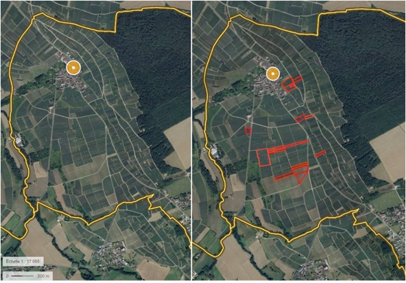
Aerial view of the Sainte-Gemme vineyard slope by Géoportail. On the right-hand photo, the Francis Orban vineyards are circled in red.
Location
Leuvrigny is in the northwestern part of the Marne department, 20 km west of Epernay.

Climate
The Leuvrigny sector has a modified oceanic climate. The episodic continental influences and relief lead to greater temperature differences as well as heavier precipitation.
The Leuvrigny sector is a reflection of the prevailing climate within the Paris basin, with relatively light winds, usually from the west. They are more frequent and stronger in winter due to the low pressure that prevails in the Paris basin. The Vallée de la Marne also helps to channel winds and influence their direction.
Most frost occurs between November and March. There may be slightly more frost at the bottom of the valley due to the accumulation of heavier cold air. The wooded cover on the slopes creates an obstacle that can protect certain areas, yet expose others by blocking the movement of cold air.
Rainfall is fairly consistent throughout the year. Because they are rougher than the vines, wooded areas slow winds and cloud cover. This phenomenon creates higher rainfall locally. In summer, the low vegetation cover on the hillsides, as opposed to the greater cover on the plateaus, causes the temperature to rise on the southern slopes. This phenomenon brings about convective air movements. When combined with precipitation, violent storms can strike and dump several centimetres of water in just a few hours.
The vines bring a sense of evenness to the landscape. Their colours change with the seasons. In spring, the hillsides are adorned with various shades of green, depending on growth stages, which differ according to vine variety and vineyard area. In autumn, reds and browns gradually appear in the vineyard as the leaves prepare to fall in a blaze of glory before giving way to the sad brown of the land in winter.
Leuvrigny, a World Heritage Site
On 4 July 2015, the “Champagne Hillsides, Houses and Cellars” were added to the UNESCO World Heritage List, in the category of living and evolving “Cultural Landscapes”!
This recognises their outstanding universal value.
The “Champagne Hillsides, Houses and Cellars” are presented as the cultural landscape which gave birth to the wine of Champagne, and which include all the work of production, development, distribution of Champagne wines transmitted and preserved in the 319 municipalities of the AOC Champagne area.
Vallée de la Marne
Spanning 514 km, the Marne is the longest river in France.
With its source in the Langres plateau (Balesmes-sur-Marne, Haute-Marne), it flows from east to west, joining the Seine between Charenton-le-Pont and Alfortville. Leuvrigny is part of the Marne basin, through the sub-basin of the Flagot rivulet which joins the Marne in the village of Mareuille-Port.

Vallée du Flagot
The Île de France plateau is split in half by the Marne, whose narrow width has created runoff in the form of small streams perpendicular to the main drain, forming a multitude of valleys that join the Vallée de la Marne. This is also true for the Vallée du Flagot.
The Flagot begins in Igny before being joined by various rivers including the Billet rivulet and the Colinière at Leuvrigny.
The Vallée du Flagot forms a trench within the slopes of the Vallée de la Marne. It is narrow at its southern entrance, at an altitude of 91 m. Then the valley widens and stretches north to the route nationale 3, at an altitude of 70 m. Then, the Flagot enters the Vallée de la Marne and winds for another 900 m before flowing into the Marne.
The hillsides are steep on both sides of this valley, and the altitude rises rapidly towards the wooded plateau of Brie.
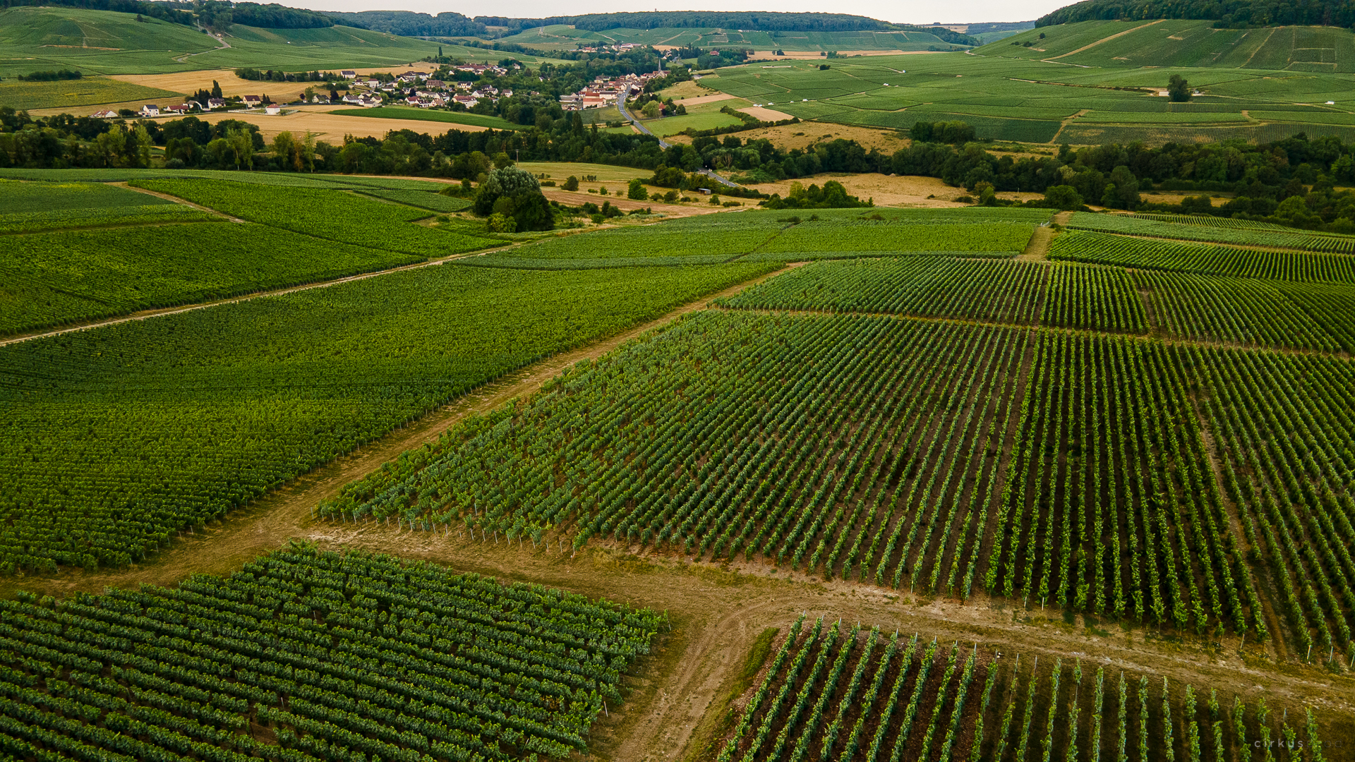
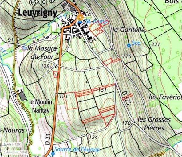
The Leuvrigny vines grow halfway up the eastern hillside of the Vallée du Flagot, at an altitude of between 85 m and 220 m. On the edge of the wooded Brie plateau in the hamlet of Le Chêne la Reine, there is a unique panorama overlooking the Vallée du Flagot and the majestic hill topped by a chestnut wood.
Water is omnipresent in the area, with three wells, five springs with two washhouses and a large number of small springs.
The area used to be mined for its raw materials, with a marl quarry and several buhrstone quarries providing building materials for the fortifications of Paris, limestone, brick and tile earth, and sand in abundance.
Sainte-Gemme wine-growing slope highlighted (Géoportail), with the location of the parcels and villages of Francis Orban. Note that the parcels fall under three different sectors on the hillside: lower, middle or mid-slope and upper.
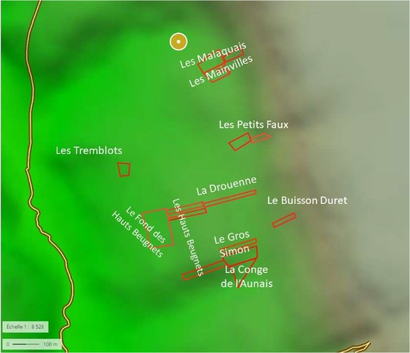
Francis Orban parcel in IGN format (Géoportail).
The three sectors are clearly delineated. They are all located to the south of the village of Leuvrigny, most exposed south-west, evolving south for La Conge de l’Aunais and Le Gros Simon (the cru’s southern area).
The slope has two points of inflection. The first is at an altitude of around 125 m, where the concave hillside (average slope of 12% with a peak of 30%) gives way to a structural flat area (average slope of 3%). The other marks the end of the flat area, at an altitude of around 150 m, where the slopes become steeper (18% on average, reaching a high of 45%).
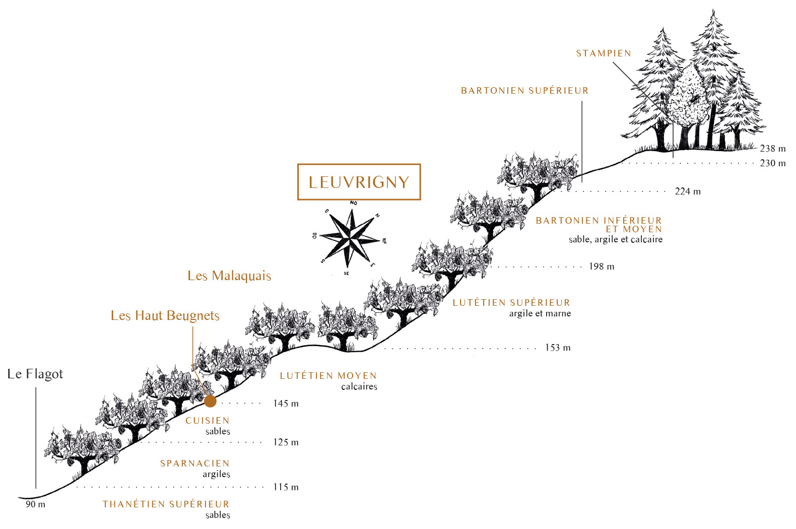
Geological history
At the base of the hillside is chalk from the Upper Cretaceous from the Secondary age, topped by Flagot alluvium topped by slope colluvium. The entire slope is represented by formations from the Tertiary Era, composed of loose rocks (sand, clay, marl) intercalated with harder or coherent rocks (limestone, sandstone), and capped in the summit position by buhrstone. The sector features several marine transgressions which left behind deposits with varying degrees of thickness.
The town is in the Paris sedimentary basin, which can be schematically represented as a stack of various types of layers that erosion has gradually released. The tertiary levels are especially visible on the slopes, where the valleys have cut them. At the foot of the slope and at the bottom of the valley, the secondary terrains (Cretaceous chalk) are often masked by more recent superficial formations.
In the sector, the Upper Cretaceous chalk does not outcrop at the level of the slope but forms the base of the hillside. The chalk sea retreated about 70 million years ago. The chalk underwent erosion for 10 million years.
The sea returned during the upper Thanetian and deposited fine coastal sands – some white, some red – when loaded with iron oxides. The sea retreated towards the northwest, forming small lakes where limestone sediments were deposited.
During the Sparnacian, a laguno-continental system developed, during which predominantly clay elements were deposited, which may be the source of a spring.
The sea returned during the Cuisian period and deposited fine coastal continental sands of marine origin, local clay sometimes hardened with sandstone. Beginning of the vineyard.
The sea returned during the Mid Lutetian in a laguno-marine system with fossiliferous limestone deposits forming a flat slope. This formation is topped with a layer of green and white marl.
The sea withdrew during the Upper Lutetian and gave way to a laguno-lacustrine system with deposits of clay, then marl with limestone beds. End of the vineyard.
The sea returned somewhat to the sector then the laguno-lacustrine system persisted in the Bartonian. Above the green clay of the mid-Bartonian are lacustrine limestone beds, then marl. Silicified limestone was deposited during the Upper Bartonian This hard base forms the main framework at the top of the slopes with underlying limestone beds.
During the Sannoisian, a laguno-marine system gave way to advancing seas which would be the last in the sector and in Champagne. Clay-siliceous deposits reworked by the continental erosion which followed led to the accumulation of clay with buhrstone fragments within clay silt. This formation is topped with plateau silts.
Erosion carved out valleys, created landslides and reworked the geological layers in place (subsoils), giving rise to colluvium on the slopes which reshuffled the ground maps. The Upper Lutetian formations are particularly noticeable in the sector and generate marl-limestone scree which sometimes accumulates in great thicknesses on the lower part of the formation and on the underlying layers.
Schematic geological section
of the southern slope of Leuvrigny
The diagram shows alternating layers of sand, limestone, clay and marl, with predominant limestone and sandy formations.
Sensory geology of the Francis Orban parcel
Total estate: 5 ha 34 a 24 ca
91,36 % Meunier
8, 64 % Chardonnay
| Sector | Place name | Land register | Geology | Microtoponymy | Grape variety | PG | Area (are) | Year planted |
|---|---|---|---|---|---|---|---|---|
| Uper | Les Mainvilles | AM0795P | Limestone | Magna villa: major villa, smallholding or centre of agricultural production | Meunier | 41B | 14,25 | 1983 : 4,93 a 1989 : 6,45 a 2000 : 2,87 a |
| Uper | Les Malaquais | AM0355 | Clay and marl | Comes from “mal acquêt”, the name for a bad property acquired by a spouse during marriage. The parcel was virgin, covered with bushes and shrubs. | Meunier | 41B | 1,66 | 1992 |
| AM0524 | Clay and marl | Meunier | 41B | 17,25 | 1975 | |||
| AM0805 | Clay and marl | Meunier | 41B | 1,51 | 1975 | |||
| AM0807 | Clay and marl | Meunier | 41B | 2,73 | 1975 | |||
| AM0671 | Limestone | Chardonnay | 41B | 1,66 | 2009 | |||
| AM0794 | Limestone | Chardonnay | 41B | 44,50 | 2008 : 35 a 2009 : 9,5 a |
|||
| Uper | Le Buisson Duret | AI0175 | Clay and marl | Duret = privet | Meunier | 41B | 12,12 | 1977 |
| AI0176 | Clay and marl | Meunier | 41B | 3,32 | 1977 | |||
| Uper | Les Petits Faux | AM0256 | Clay and marl | Small beeches | Meunier | 41B | 3,62 | 1966 |
| AM0290 | Clay and marl | Meunier | 41B | 8,08 | 1962 | |||
| AM0295 | Clay and marl | Meunier | 41B | 6,24 | 1979 | |||
| AM0296 | Clay and marl | Meunier | 41B | 5,61 | 1983 | |||
| AM0760 | Limestone | Meunier | 41B | 0,73 | 1986 | |||
| AM0768 | Limestone | Meunier | 41B | 7,66 | 1983 : 3,58 a 1985 : 0,5 a 1986 : 3,48 a |
|||
| AM0769 | Limestone | Meunier | 41B | 5,39 | 1983 : 2,71 a 1985 : 0,48 a 1986 : 2,2 a |
|||
| Mid-slope | Le Gros Simon | AL0127 | Limestone | Description of Simon | Meunier | 41B | 22,25 | 1982 |
| Mid-slope | AL0118 | Limestone | Meunier | 41B | 33,04 | 1982 : 27 a 1983 : 2,5 a / 3,54 a |
||
| Mid-slope | AL0130 | Limestone | Meunier | 41B | 55,01 | 1971 : 18 a 1973 : 37,01 a |
||
| Mid-slope | Les Hauts Beugnets | AL0144 | Sand and limestone | Beugne = bump or rounded top, therefore beugnet with the diminutive | Meunier | 41B | 26,69 | 1971 |
| Mid-slope | AL0 | Sand and limestone | Meunier | 41B | 21,49 | 1963 : 11,10 a 1968 : 10,39 a |
||
| Mid-slope | AL0092 | Sand and limestone | Meunier | 41B | 14,50 | 1973 : 9,26 a 1984 : 5,24 a |
||
| Mid-slope | AL0094 | Sand and limestone | Meunier | 41B | 4,74 | 1973 | ||
| Mid-slope | AL0095 | Sand and limestone | Meunier | 41B | 7,11 | 1984 : 2 a 1985 : 5,11 a |
||
| Mid-slope | AL0088 | Limestone | Roman capacity measurement | Meunier | 41B | 44,26 | 1971 | |
| Mid-slope | La Drouenne | AL0117 | Limestone | Spring? (douenne from the Gallic Andounna = spring) | Meunier | 41B | 16,36 | 1981 : 9,72 a 1983 : 6,64 a |
| Mid-slope | AL0146 | Limestone | Meunier | 41B | 10,28 | 1981 | ||
| Lower | Les Tremblots | AL0058 | Sand | From the Latin tremulus, from trembling poplar | Meunier | 41B | 18,30 | 1959 |
| Lower | Les Fonds des Hautes Beugnet | AL0162 | Sand | Bottom of the bump | Meunier | 41B | 49,03 | 1964 : 32,18 a 1984 : 4,85 a 1988 : 12 a |
| Lower | AL0173 | Sand | Meunier | 41B | 34,48 | 1964 | ||
| Lower | AL0174 | Sand | Meunier | 41B | 40,37 | 1987 : 12 a 1991 : 10 a 1992 : 10 a 1993 : 8,37 a |
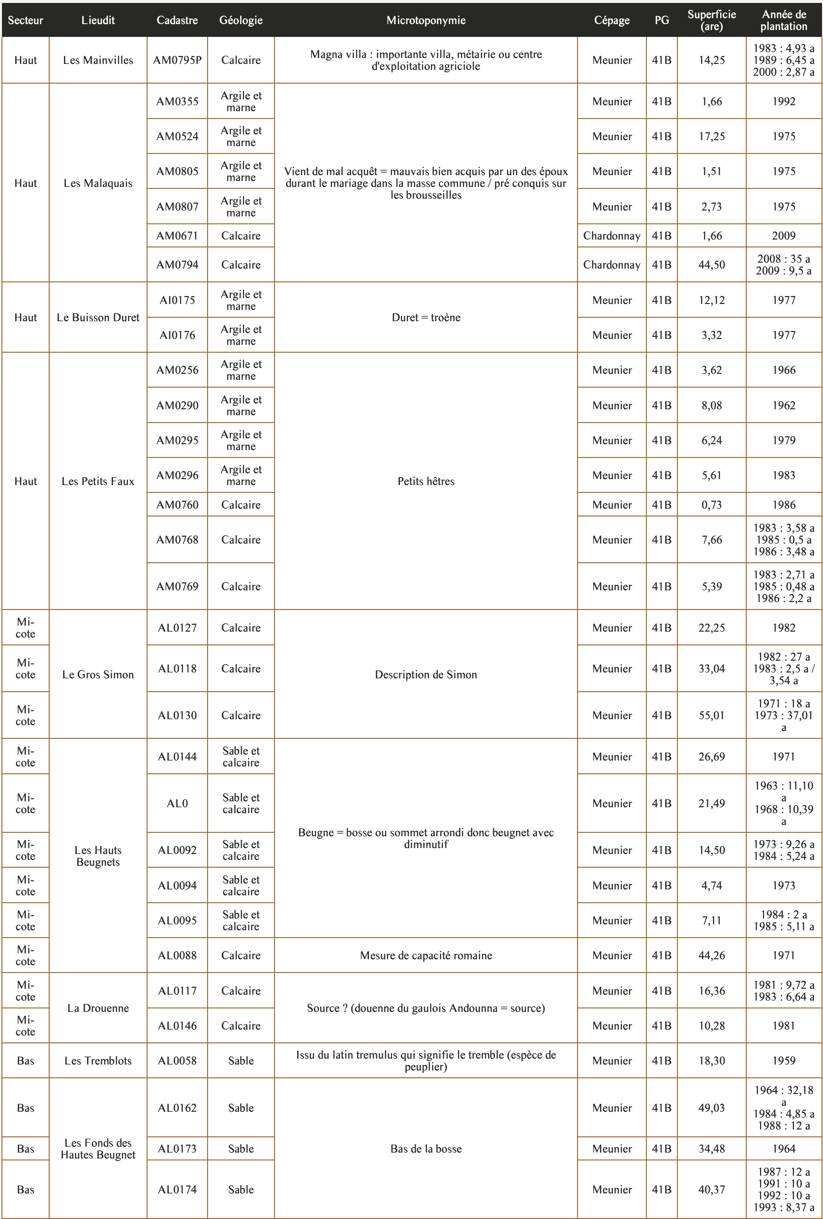
Summary table of the Champagne Francis Orban parcels.
Soil type
47,8 %
Limestone
26,6 %
Sand
14,0 %
Sand and limestone
11,6 %
Clay and marl
Geological history
A parcel study of the estate shows that 90% of the vineyard is planted on limestone and sandy formations. The remaining 10% are layers of various forms of clay and marl, sometimes with green clay. Note that Chardonnay is grown only on limestone formations.
The sandy and limestone formations bring a frankness to the wine, with some seabreeze salinity (depending on whether or not there are marine fossils in the ground) and length on the palate, with a more intense tension and limestone expression on the finish (and therefore more ageing potential) than the sand.
Chardonnay on limestone generally reacts with notes of lemon, acacia flowers, white peach, verbena, apple, pear, almond, hazelnut, and with accents of Carensac liquorice and aniseed. Its freshness is expressed with lemon acidity.
Meunier grown in sand takes on citrus and tropical fruit notes such as orange, mandarin, clementine, kumquat, passion fruit, peach and pineapple. Its sharp, chiselled suppleness and freshness make it a perfect choice for pre-dinner drinks.
Meunier grown in limestone also shows citrus and exotic freshness while revealing variable notes of red fruit (strawberry, raspberry), black fruit (blackberry, blackcurrant), white fruit (pippin apple, pear) and floral freshness (rose, orange).
Meunier on clay and on clay-marl takes on more volume on the palate, with increased mouthfeel (partial drying of the mucous membranes) and dominates the mid-palate. It then brings fleshier notes such as apple, quince, peach, almond, red and black fruit, mango, Mirabelle plum, ginger, gingerbread, honey, praline, heady rose, cumin and other sweet spices. Note that some parcels benefit from both sand and limestone, which brings together all the conditions for appealing aromatic freshness.
This overall freshness in Leuvrigny comes in addition to its southwest exposure and the presence of a spring or temporary aquifers in the subsoil. However, the intensity of the slopes, the work on Meunier vegetation, the work on the soil (blade, grass cover) and the choice to respect the right harvest date on the parcel, make it possible to harvest the Meunier grapes at peak ripeness and to maintain their freshness. Moreover, the reduction effect of limestone and sand is maintained in vinification by working on the lees and shielding the wine from oxygen as much as possible (without veering towards poor reduction).
Parcel diversity is a formidable tool. On the one hand to enhance the blending of qualities that are specific to different parcels, on the other to underline the quality and distinctive character of one or more parcels in its terroir, to increase awareness and appreciation of it.
This parcel diversity combines the influences of geology, pedology, sun exposure, microclimate, altitude, air masses, humidity, grape varieties and the approach of the winemaker. Francis perpetuates the know-how of the growers who went before him, while developing an approach that is more attentive to the soil, the plant and its ecosystem, according to his personal convictions and the annual cycles of nature.

Some local history
The name of Leuvrigny comes from the Latin Laura ignita, which means “burnt monastery”.
There is a hamlet in Leuvrigny known as Le Chêne la Reine, which takes its name from a series of events that occurred there many years ago. In an attempt to flee from her enemies, Queen Blanche of Castile sought refuge and protection in the hollow trunk of the oldest oak tree in the forest for one day and one night.
Queen Marie-Antoinette is said to have stopped in the shade of the large oak tree during a hunt.
The Queen noticed that her beautiful silver comb, a gift from her beloved mother, had disappeared. Her squires, valets, guests, ladies-in-waiting and even the woodcutters searched high and low, over paths, in thickets and through copses. One poor woodcutter, so simple and modest that his hut occupied the tiniest, most remote corner of the clearing, found the treasure. To the Queen’s delight, he brought it to her, and she congratulated him, presenting him with her purse. The gold coins it contained were used to build a real village around the lucky oak tree, a truly happy village. The grateful inhabitants called it “Le Chêne la Reine” (the queen’s oak) while at the end of the clearing, the modest and understated hut was forever known as “Le Peigne d'Argent” (the silver comb).
More recently, Leuvrigny was awarded the Croix de Guerre for citation at the order of the Army in June 1921 during the 1914-1918 campaign against Germany and its allies. A large number of homes were destroyed by fighting during the Battle of the Marne. A new church building was erected in 1925 using buhrstone damaged by the war that had been extracted from local quarries.